Hawaiian International Flight Reports for March 2000
8.30.99
Hawaiian International Flight Reports for March 2000
Flight Reports are placed here from our famous world class pilots.
They are reported in the order in which I recieve them ie: The first one who files gets the first listing.
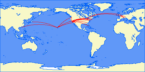
Map courtesy of Patrick Richardson
Click on Pilot's name (if in link format) to see their report.
|
|
|
Reza Gorji
March 2000 Flights HI30 HNL Honolulu, HI. OGG Kahului, HI. A320 I 20.00 HI31 OGG Kahului, HI. HNL Honolulu, HI. A320 I 20.00 HI40 HNL Honolulu, HI. Hana Dash 8 V 45.00 Via Kalaupapa HI41 Hana HNL Honolulu, HI. Dash 8 V 43.00 Via Kalaupapa HI54 HNL Honolulu, HI. MKK Kaunakakai Dash 8 V 15.00 HI55 MKK Kaunakakai, HI HNL Honolulu, HI. Dash 8 V 15.00 HI56 HNL Honolulu, HI. Kalaupapa Dash 8 V 35.00 HI57 Kalaupapa HNL Honolulu, HI. Dash 8 V 35.00 HI65 HNL Honolulu, HI. ITO Hilo, HI A320 I 35.00 HI66 ITO Hilo, HI HNL Honolulu, HI. A320 I 35.00 HI82 HNL Honolulu, HI. LIH Lihue, HI. A320 I 20.00 HI83 LIH Lihue, HI. HNL Honolulu, HI. A320 I 25.00 HI84 HNL Honolulu, HI. LIH Lihue, HI. A320 I 25.00 HI85 LIH Lihue, HI. HNL Honolulu, HI. A320 I 25.00 HI88 HNL Honolulu, HI. LIH Lihue, HI. A320 I 25.00 HI89 LIH Lihue, HI. HNL Honolulu, HI. A320 I 25.00 HI107 ITO Hilo, HI LNY Lanai Dash 8 V 40.00 via Kona HI211 HNL #N/A Johnston Atoll A320 I 135.00 HI212 Johnston Atoll HNL Honolulu, HI. A320 I 140.00 HI213 HNL Honolulu, HI. Midway Atoll/Sand Island, MQ. A320 I 150.00 HI214 Midway Atoll/Sand Island, MQ. HNL Honolulu, HI. A320 I 155.00 HI622 MIA Miami Nassau Bahamas Dash 8 V 50.00 HI623 Nassau, Bahamas MIA Miami Dash 8 V 55.00 HI701 Papeete Moorea Cessna V 10.00 HI702 Moorea Papeete Cessna V 10.00 HI703 Papeete Moorea Cessna V 10.00 HI704 Moorea Papeete Cessna V 10.00 Total Time= 1208.00 MINUTES # OF FLIGHTS 27 SEGMENTS
ALL flights were unevenful and very very enjoyable. Only exception was flight to Lanai which was difficult landing due to being overspeed.
Bruce Buffa
Here are my flight reports for March 2000 -
HI302 New York (KJFK) to Washington National (KDCA) - 737 - 184 miles, 42 minutes
HI303 Washington National (KDCA) to New York (KJFK) - 737 - 183 miles, 51 minutes
HI306 New York (KJFK) to Philidelphia (KPHL) - EMB-120 - 81 miles, 34 minutes
HI307 Philidelphia (KPHL) to New York (KJFK) - EMB-120 - 83 miles, 35 minutes
HI407 Miami (KMIA) to Key West (KEYW) - ATR - 108 miles, 49 minutes
HI408 Key West (KEYW) to Miami (KMIA) - ATR - 108 miles, 49 minutes
Total flights - 6
Total segments - 6
Total time - 4 hours, 20 minutes
No problems reported.
Dean Georgaris
FLIGHTS FOR DEAN GEORGARIS, MARCH 2000
HI Flight #12 - 737-300 PHNL to PHKO. Departed on time @ 11:02. Cruise
at 16,000 feet for a 36 minute flight. Slight crosswind (12@220) on landing
at runway 17.
HI flight #13 - 737-300 PHKO to PHNL. Departed on time @ 12:04. Flew
Amery one departure, approx. 2 minutes into flight while completing climbing
right turn to 270, encountered Cessna 172 that the tower didn't see and had
to add power to avoid. Nothing so drastic that the passengers would know,
but filed report with FAA. Otherwise uneventful cruise @15,000 feet. 34
minute flight time. Slight crosswind on landing at runway 22.
HI flight #14 - 737-300 PHNL to PHKO. MTOW. Departed late @ 16:15 to await
connecting passengers. Cruise @ 18k ft. Made up time with direct IFR. 29
minute flight. Soft landing on runway 17.
Hi flight #15 - 737-300 PHKO to PHNL. Departed on time @17:00 after fast
turnaround. IFR to PHNL @ 15k feet. Originally cleared for runway 22, but
tower changed it to 08 after a windshear alert was issued. No problems on
approach or landing. 42 minute flight with re-route.
Hi flight #16 - 737-300 PHNL to PHKO. Departed on time @19:03. Clear skies,
no wind. Milk run @ 16K ft. 32 minute flight and direct approach to runway
17. In early
Hi flight #17 - 737-300 PHKO to PHNL. Departed on time @20:02. Passengers
had stunning views all the way up the islands. Not a single bump or bounce.
Entered landing pattern for 08. Right side of the plane got an aerial tour
of the capital. Slowed for traffic, otherwise a great night to fly. 38
minute flight time.
HI 90 -- 737-300. Departed on time at 1002. Took off with 39200 lb payload
and 7967 lb fuel. Flew Palay two departure to Lanai VOR and then into
Maui. Cruise 13,000 ft. Landed at Kahuli on runway 02. On time
turnaround, departed on runway 02 at near MTOW with 45010 payload and 7354
lbs of fuel. Flew Beach one departure, made transition at MAKEN to V5.
Cruise @ 13,000 ft, then vectors to Kona runway 17. At the gate 5 mins
early.
HI 91 -- 737-300. Left on time at 1406. Light load, only 20154lbs payload.
7120 lbs fuel. Took off to the south on runway 17, then made climbing right
turn to 297 per Amery One departure. Flew ANDES to V20. Made transition at
ROWIN, from there radar vectors into Kahuli. Crusie @12,000ft. Nose gear
indicated malfunction, recycled gear, and got all greens. Landed to the
north on runway 02. At gate on time. Departed after slow turnaround due to
check on the nose gear. Faulty sensor replaced. MTOW with 45010 and 7354lbs
of fuel. Took off Runway 02, climbing left turn to intercept V15 at LORET.
Cruise @12,000ft From there to V8 at Molokai and then radar vectors south
of honolulu for landing on runway 04. Flew 5 degree glide slope per tower.
Landed with full flaps, nearly 70% power in gusty conditions. Near but
under MLW.
HI FLIGHT #620 -- The 7am "breakfast run" from Miami to Nassau, Bahamas.
We flew a full 737-300 of happy passengers. With baggage and fuel we were
near MTOW (42323 + 7967). Departed runway 09R at 7:14 AM - climbed through
bumpy air between 3 and 10k feet up to a cruising altitude of 23,000 feet.
The left side of the plane got the better view on this particular flight,
including crystal clear looks at Bimini and the outer Cays. We were the
only flight coming in that early, so approach cleared us straight in to
runway 9. Only bad part of the flight was the incredibly long taxi to the
ramp. In at 7:49. Burned 3787 lbs fuel.
Hi FLIGHT #621 -- The 8:20am "Vacation's over run" from Nassau, Bahamas to
Miami. A capacity 737-300 this Monday Morning. MTOW with 42323 + 8171.
Active runway was 09, so after a nearly ten minute taxi, we departed at
8:31am. Made a climbing left turn and followed jetways at 22,000 feet.
Route was longer, so descended fast south of the Miami area to make up a
little time, and were vectored onto final for 09R. One notch flaps, soft
landing, long roll out so that we could make it to the gate on-time. Burned
4017 lbs fuel
Bruno Glaviano
Flights:
HI 002 San Francisco Chicago Boeing 747-400 (PS1) 3 hours 42 min, 1732 NM. This has been an interesting flight: because of my ignorance on the fuel system, fuel was unbalanced and I had to read all the manuals before correcting it. Then I had to leave and I left the flight to AP, when I came back, the fuel was balanced but I lost some electrical generators and autoland with them. I reset the fuel pumps to the tank to engine configuration, the generators restarted and I could land safely and smoothly.
HI 004 London Milan Boeing 747-400, 1 hour 20 minutes, 554 NM. This was a PS1 flight, to carry the passengers in this leg of the luxurious world tour. Approach to runway 35R coming from North is rather steep, but with some manual intervention the procedure was successfully completed.
HI 50 Honolulu Molokai King-Air 16 min, 52 NM. I had to use this plane instead of the ATR, because there where few passengers, and I don‚t have a 5.21 ATR yet. Nice flight.
HI 51 Molokai Honolulu King-Air 16 min 53 NM: Nice IFR flight back, landing as usual on runway 26L
HI 650 Milan Munich Vienna Airbus A-320 1hour 18 min 463 NM. First flight with the latest 5.21 version of X-Plane, and with the excellent A320. The second leg was flown with another version of the plane, to test some new instruments in the cockpit.
HI 652 Milan Geneva Airbus A-320 26 min 132 NM: Nice flight, with spectacular crossino of the Alps. But, leaving Geneva for Paris, soon after PAS VOR X-Plane crashed. The same problem has been noted by other European Xplaners flying in the area, and stil is a mystery. To complete the flight, I took a 747-400 from PS1 and reached Paris in 44 min, 234NM travel. This has been an uneventful IFR flight, but not very comfortable for turbulence (real weather).
HI 710 Huahine Raiatea Bora Bora ATR-42 22 min, 66 NM. Flight included some sight-seeing over the islands.
HI 715 Tahiti Tangiroa Tikehau Mataiva ATR-42 1h 10 min, 272 NM. Uneventful flight to Rangiroa, with a nice view over Mataiva, then two short and interesting jumps to the smaller atolls. The extra concentration required to land the short runways, resulted in excellent landings.
, #of Hours: 9 h 34 min, Problems:
X-Plane crashes after take-off from Geneva LSGG. other european pilots active in the area reported the same problem. After I upgraded to version 5.23 the problem disappeared., Submit
---------------------------------------------------------------------------
(Flight Segment) Flight Segments: 13
Jonathan Hay
FLGT # Type Dep Dest TOD TOA TIF TFT
EMB120 KMIA KRSW 12:08 12:44 00:36
KRSW KMIA 01:13 01:55 00:42 01:18
MD80 KMIA KTPA 12:17 13:10 00:53
KTPA KMIA 18:55 19:33 00:38 01:31
B737 KMIA KMCO 18:37 19:22 00:45
KMCO KMIA 06:16 07:08 00:52 01:37
B757 KJFK KDCA 13:19 14:07 00:48
KDCA KJFK 14:14 14:45 00:31 01:19, #of Hours:05:45, Problems:, Submit
---------------------------------------------------------------------------
(Flight Segment) Flight Segments:6
Terrance Henderson
March, 3-28-00, Flights:
HI FLT 61
Dep: Honolulu PHNL
Arrival: Hilo PHTO
Dep time: ON TIME 0630A
B757 N023HI
FL230
Time Enroute: 00:32:00 minutes
Comments: none
HI FLT 62
Dep: Hilo PHTO
Arrival: Honolulu PHNL
Dep time: ON TIME 0730A
B757 N023HI
FL220
Time Enroute: 00:30:00 minutes
Comments: none
HI FLT 86
Dep: Honolulu PHNL
Arrival: Lihue PHLI
Dep time: ON TIME 1800
B757 N1496HI
FL180
Time Enroute: 00:21:00 minutes
Comments: none
HI FLT 87
Dep: Lihue PHLI
Arrival: Honolulu PHNL
Dep time: ON TIME 1900
B757 N1496HI
FL140
Time Enroute: 00:18:00 minutes
Comments: none
HI FLT 104
Dep: Lanai
Arrival: Lihue
Stop: Honolulu PHNL
Dep time: ON TIME 1900
CRJ100 N56HI
FL110
Time Enroute Leg 1: 00:11:00 minutes
Time Enroute Leg 2: 00:21:00 minutes
Comments: Accident (see report:)
HI FLT 105
Dep: Lihue
Arrival: Lanai
Stop: Honolulu PHNL
Dep time: ON TIME 2000
CRJ100 N56HI
FL110
Time Enroute Leg 1: 00:10:00 minutes
Time Enroute Leg 2: 00:20:00 minutes
Comments:
HI FLT 208
Dep: Honolulu PHNL
Arrival: Hong Kong VHHH
Dep time: ON TIME 1100
B747-400 N682HI
FL320
Time Enroute: 10:18:00 minutes (10.4)
Comments: none
HI FLT 209
Dep: Hong Kong VHHH
Arrival: Honolulu PHNL
Dep time: ON TIME 2120
B747-400 N682HI
FL330
Time Enroute: 09:14:00 minutes (9.3)
Comments: none, 22.7, Problems:
------------------------------------------------------------------------------
NTSB ACCIDENT REPORT 0334852
CANADIAR CRJ100
registration: N56HI sn0041277
HAWAIIAN INTERNATIONAL AIRLINES
FLIGHT 104 - Lanai City-Honolulu
Fatalities 0:17
Crew: Capt Terrance Henderson
FO: Sean Hogan
Aircraft experienced partial control loss (joystick died) on localizer approach
to Hawaiian international airport during execution of a left turn
onto runway 26L. executed goaround TOGA using autopilot for control. Aircraft approached
runway 26R for emergency landing, touched down right if centerline. due to the control
loss the aircraft veered off and departed the runway at the 1600 feet mark.
No injuries to passengers or crew. damage to aircraft landing gear.
passengers debrief and continued flight
to final dest. in Lihue on a backup airplane.
Corrected problem: reloaded joystick software. It had been a little unstable lately
What a way to end the month!!
, FYI:
First Officer Name are actual friend of mine who fly for
the airlines as captains: UAL, FEDEX execpt for
Sean Hogan who was my post president in boy scouts aviation
exploring post and eagle scout who now flys commuters for
USAIR in Boston MA
I wish the congratulation in their demotion in Hawaiian International - laughs, Submit
---------------------------------------------------------------------------
(Flight Segment) 10
Orion Kingman
Flight No. Pilot Departure Destination Time off Plane Stops Time in Total Time Comments HI204 Capt. Kingman KLAX PHNL 2000 747-400 None 50 4.8 HI74 Capt. Kingman PHNL PHNY 1800 G-5 PHLI 1850 0.83 Overcast @ PHLI HI75 Capt. Kingman PHNY PHNL 2100 G-5 PHLI 2154 0.9 HI189 Capt. Kingman PHLI PHLI 800 Sabb 340 None 900 1 Total Logged Time= 7.53
Brandon Kelmers
Brandon Kelmers, March, 3/17/00, HI33: 20 minutes HI34: 22 minutes HI35: 19 minutes HI36: 21 minutes HI37: 22 minutes, 1 hr 44 min, none, I would like to request another set of flights assigned to me please., Submit
(Flight Segment) 2.5
Brandon Kelmers, March, 3/18/00, HI94: 34 minutes HI95: 31 minutes HI98: 12 minutes HI99: 13 minutes, 1 hr 29 min, none, Submit
(Flight Segment) 2
March, 3/19/00, HI186: 18 minutes, [flew the Albatross, weather was nice and sunny] HI409: 24 minutes, [flew 737, good weather], 0 hrs 42 min, none, I have been having some trouble getting the planes I download from this site to work. It keeps saying that they have been created with an earlier version of X-Plane and will not use the plane. Do you have any planes that will work with version 5.22?, Submit
(Flight Segment) 2
|
Brandon Kelmers, March, 3/20/00`, HI628: 46 min HI629: 51 min HI204: (See note below), 1 hr 37 min , none, |
I will not be able to fly HI204, Honolulu to Auckland, because I think there is a glitch in my software because, first of all, the GPS in my plane will not give me accurate distances to Auckland. And the GPS points me East (91 degrees) instead of South., Submit |
|
(Flight Segment) 1 |
Brandon Kelmers, March, 3/23/00, HI204: 3 hrs 17 min [ flew Concorde ], 3 hr 17 min, Approximately 19 minutes into the flight, Engine #3 failed. I declared an emergency and made an emergency landing at the nearest airfield: Barber's Point NAS. Fixed engine and resumed flight., Submit
(Flight Segment) 1
John Landry
Chris Monson
Flights:
HNL-HTO 44 min
HTO-HNL 35 min
HNL-HKO 37 min
HKO-HNL 27 min
HNL-HOG 22 min
HOG-HNL 20 min
HNL-HMK 25 min
HMK-HNL 23 min
HNL-HNY 25 min
HNY-HNL 35 min
HNL-HLI 27 min
HLI-HNL 32 min
Miami-Guantanamo Bay 1 hr 27 min
Guantanamo Bay-Miami 1 hr 21 min
, #of Hours: 8 hrs 40 min, Problems:
HNL-HKO Missed approach due to strong crosswind, Submit
---------------------------------------------------------------------------
(Flight Segment) Flight Segments: 14
Barrie Myers
I give below the flight reports of the flights I have made in March
Barrie Myers
HI10 HONOLULU INTERNATIONAL (PHNL) TO KONA (PHKO)
Take off at 0600 and at the ramp at Kona at 0635
Total time 35 minutes, cruising height 10,000 feet
Aircraft 737, fuel used 3725 lbs, distance 142 miles
No problems
HI11 KONA (PHKO) TO HONOLULU INTERNATIONAL (PHNL)
Take off at 0700 and at the ramp at Honolulu at 0737
Total time 37 minutes, cruising height 10,000 feet
Aircraft 737, fuel used 3928 lbs, distance 142 miles
No problems
HI102 HONOLULU INTERNATIONAL (PHNL) TO HANALEI, PRINCEVILLE (HI01)
Take off at 2000 and at the ramp at Princeville at 2041
Total time 41 minutes, cruising height 6,000 feet
Aircraft EMB, fuel used 725 lbs, distance 100 miles
No problems except missed approach
HI103 HANALEI, PRINCEVILLE (HI01) TO HONOLULU INTERNATIONAL (PHNL)
Take off at 2100 and at the ramp at Honolulu at 2134
Total time 34 minutes, cruising height 5,000 feet
Aircraft EMB, fuel used 695 lbs, distance 100 miles
No problems
HI190 LIHUE (PHLI) TO LIHUE (PHLI) SIGHTSEEING TRIP OVER ISLAND OF NIIHAU
Take off at 0900 and back at the ramp at Lihue at 0948
Total time 48 minutes, cruising height between 1,000 and 2,000 feet
Aiircraft Hawaiian Airbus 340, fuel used 9233 lbs, distaance travelled 176 miles
No problems
HI304 NEW YORK JFK (KJFK) TO PITTSBURGH INTERNATIONAL (KPIT)
Take off at 0800 and at the ramp at Pittsburgh at 0859
Total time 59 minutes, cruising height 10,000 feet
Aircraft Hawaiian 737, fuel used 8559 lbs, distance 295 miles
No problems except strong wind when landing
HI305 PITTSBURGH INTERNATIONAL (KPIT) TO NEW YORK JFK (KJFK)
Take off at 1600 and at the ramp at JFK at 1658
Total time 58 minutes, cruising height 15,000 feet
Aircraft Hawaiian 737, fuel used 8755, distance 295 miles
No problems
HI624 MIAMI INTERNATIONAL (KMIA) TO GRAND CAYMAN OWEN ROBERTS (MWCR)
Take off at 1500 and at the ramp at Grand Cayman at 1603
Total time 1 hour 3 minutes, cruising height 15,000 feet
Aircraft Hawaiian Airbus 340, fuel used 16525 lbs, distance 394 miles
No problems
HI625 GRAND CAYMAN OWEN ROBERTS (MWCR) TO MIAMI INTERNATIONAL (KMIA)
Take off at 2000 and at the rtamp at Miami at 2059
Total time 59 minutes, cruising height 20,000 feet
Aircraft Hawaiian Airbus 340, fuel used 16235 lbs, distance 394 miles
No problems
HI653 PARIS DE GAULLE (LFPG) TO MILANO LIN (LIML) STOPPING AT GENEVA (LSGG)
Take off at 1900 and at the ramp at Geneva at 1941
Time to Geneva 41 minutes, cruising height 11,000 feet
Aircraft Hawaiian A340, fuel used 9062 lbs, distance 221 miles
No problems
CONTINUATION FLIGHT MILANO LIN (LIML) TO GENEVA COINTRIN (LSGG)
Take off from Geneva at 2230 and at the ramp at Milano at 2303
Total time to Geneva 33 minutes, cruising height 16,000 feet
Aircraft Hawaiian A340, fuel used 7792 lbs, distance 143 miles
No problems
Complete flight was:
Total time Paris to Milano 1 hour 14 minutes, total fuel used was 16854 lbs,
total distance was 364 miles
Barrie Myers
TOTAL FLYING HOURS FOR MARCH
8 hours 28 minutes
Kay Nemoto
HI63 737 HNL-ITO 0:53
HI64 737 ITO-HNL 0:43
HI80 737 HNL-LIH 0:28
HI81 737 LIH-HNL 0:30
HI96 737 KOA-OGG 0:25
HI97 737 OGG-KOA 0:26, #of Hours:3:25, Problems:, Submit
---------------------------------------------------------------------------
(Flight Segment) Flight Segments:6
Brian Reel
Flights: HI311 - New York to San Fransisco : 4 hr. 50 min.
HI312 - San Fransisco to New York : 4 hr. 41 min. , #of Hours: 9 hr. 31 min., Problems:, Submit
---------------------------------------------------------------------------
(Flight Segment) Flight Segments:2
Roberto Silva
03/31/2000, Flights:
HI3 CHICAGO - LONDON B747 PS1 TIME: 07.30
, Few hours for fly this month ...
Martin Stromberg
Flights:
HI662 000303 LIMC Milan - EDDI Berlin Airbus 320 Cruise speed: 300 knots Cruise altitude: 27000 feet Time: 1h 13min
HI663 000305 EDDI Berlin - LIMC Milan Airbus 320 Cruise speed: 300 knots Cruise altitude: 23000 feet Time: 1h 19min
HI656 000317 LIMC Milan - LIRF Rome Airbus 320 Cruise speed: 300 knots Cruise altitude: 20000 feet Time: 0h 55min
HI657 000318 LIRF Rome - LIMC Milan Airbus 320 Cruise speed: 300 knots Cruise altitude: 20000 feet Time. 0h 55min
HI660 000318 LIMC Milan - LGAT Athens Airbus 320 Cruise speed: 300 knots Cruise altitude: 20000 feet Time: 2h 23min
HI661 000323 LGAT Athens - LIMC Milan Airbus 320 Cruise speed: 300 knots Cruise altitude: 20000 feet Time: 2h 12min
HI684 000325 EDDM Munich - EBBR Brussels Airbus 320 Cruise speed: 300 knots Cruise altitude: 20000 feet Time: 0h 59min
HI685 000325 EBBR Brussels - EDDM Munich Airbus 320 Cruise speed: 300 knots Cruise altitude: 20000 feet Time: 1h 05min
HI688 000329 EDDM Munich - ESSA Stockholm Airbus 320 Cruise speed: 300 knots Cruise altitude: 20000 feet Time: 2h 02min
HI689 000331 ESSA Stockholm - EDDM Munich Airbus 320 Cruise speed: 300 knots Cruise altitude: 20000 feet Time: 1h 51min
All flights with an Airbus from British Airways, #of Hours: 14hours 54minutes, Submit
---------------------------------------------------------------------------
(Flight Segment) Flight Segments: 10
Albert Tanneberg
Flight HI451
# Type: Name: Frequency: Course: Dist.: Time:
--------------------------------------------------------------------------------------------
Depart: --> San Francisco International KSFO 0 NM 20:00
Arrive: --> Los Angeles International KLAX 299 NM 20:50
========================================================================
====================
Aircraft: Airbus A320
Cruise: 400 knots, maximum range 3150 NM
Climb: 300 knots at 2500 ft/min (12 min, 60 NM)
Descend: 300 knots at 3000 ft/min (10 min, 50 NM)
========================================================================
====================
1 Depart: San Francisco International KSFO 0 NM 20:00
--> Climb to 30000 feet.
2 Waypoint: San Jose [SJC] VOR : 114.10 125° 25 NM 20:05
3 Waypoint: Panoche VOR [PXN] VOR : 112.60 125° 68 NM 20:17
4 Waypoint: Avenal VOR [AVE] VOR : 117.10 149° 75 NM 20:28
5 Waypoint: Gorman VOR [GMN] VOR : 116.10 132° 75 NM 20:39
6 Waypoint: Van Nuys [VNY] VOR : 113.10 152° 39 NM 20:47
--------------------------------------------------------------------------------------------
7 Arrive: Los Angeles International KLAX 167° 17 NM 20:50
Runway heading 69°, altitude 126 ft
========================================================================
====================
Total: (933 gallons fuel required) 299 NM 00:50
Flight HI452
# Type: Name: Frequency: Course: Dist.: Time:
--------------------------------------------------------------------------------------------
Depart: --> Los Angeles International KLAX 0 NM 18:00
Arrive: --> San Francisco International KSFO 300 NM 18:50
========================================================================
====================
Aircraft: Airbus A320
Cruise: 400 knots, maximum range 3150 NM
Climb: 300 knots at 2500 ft/min (12 min, 60 NM)
Descend: 300 knots at 3000 ft/min (10 min, 50 NM)
========================================================================
====================
1 Depart: Los Angeles International KLAX 0 NM 18:00
--> Climb to 30000 feet.
2 Waypoint: Fillmore VOR [FIM] VOR : 112.50 317° 34 NM 18:07
3 Waypoint: Fellows VOR [FLW] VOR : 117.50 313° 66 NM 18:18
4 Waypoint: Priest [ROM] VOR : 110.00 328° 74 NM 18:29
5 Waypoint: Salinas VOR [SNS] VOR : 117.30 305° 55 NM 18:37
6 Waypoint: San Jose [SJC] VOR : 114.10 339° 46 NM 18:45
--------------------------------------------------------------------------------------------
7 Arrive: San Francisco International KSFO 306° 25 NM 18:50
Runway heading 12°, altitude 11 ft
========================================================================
====================
Total: (933 gallons fuel required) 300 NM 00:50
Flight HI453
# Type: Name: Frequency: Course: Dist.: Time:
--------------------------------------------------------------------------------------------
Depart: --> San Francisco International KSFO 0 NM 19:00
Arrive: --> San Diego International-Lindb KSAN 395 NM 20:06
========================================================================
====================
Aircraft: Airbus A320
Cruise: 400 knots, maximum range 3150 NM
Climb: 300 knots at 2500 ft/min (14 min, 70 NM)
Descend: 300 knots at 3000 ft/min (12 min, 60 NM)
========================================================================
====================
1 Depart: San Francisco International KSFO 0 NM 19:00
--> Climb to 35000 feet.
2 Waypoint: San Jose [SJC] VOR : 114.10 125° 25 NM 19:05
3 Waypoint: Salinas VOR [SNS] VOR : 117.30 159° 46 NM 19:14
4 Waypoint: Priest [ROM] VOR : 110.00 124° 55 NM 19:22
5 Waypoint: Fellows VOR [FLW] VOR : 117.50 148° 74 NM 19:33
6 Waypoint: Fillmore VOR [FIM] VOR : 112.50 132° 66 NM 19:43
--------------------------------------------------------------------------------------------
7 Arrive: San Diego International-Lindb KSAN 139° 129 NM 20:06
Runway heading 93°, altitude 14 ft
========================================================================
====================
Total: (1189 gallons fuel required) 395 NM 01:06
Flight HI454
# Type: Name: Frequency: Course: Dist.: Time:
--------------------------------------------------------------------------------------------
Depart: --> San Diego International-Lindb KSAN 0 NM 21:00
Arrive: --> San Francisco International KSFO 398 NM 22:07
========================================================================
====================
Aircraft: Airbus A320
Cruise: 400 knots, maximum range 3150 NM
Climb: 300 knots at 2500 ft/min (14 min, 70 NM)
Descend: 300 knots at 3000 ft/min (12 min, 60 NM)
========================================================================
====================
1 Depart: San Diego International-Lindb KSAN 0 NM 21:00
--> Climb to 35000 feet.
2 Waypoint: El Toro VOR [NZJ] VOR : 117.20 334° 63 NM 21:13
3 Waypoint: Lake Hughes VOR [LHS] VOR : 108.40 325° 74 NM 21:24
4 Waypoint: Avenal VOR [AVE] VOR : 117.10 310° 90 NM 21:38
5 Waypoint: Priest [ROM] VOR : 110.00 312° 45 NM 21:45
6 Waypoint: Salinas VOR [SNS] VOR : 117.30 305° 55 NM 21:53
7 Waypoint: San Jose [SJC] VOR : 114.10 339° 46 NM 22:02
--------------------------------------------------------------------------------------------
8 Arrive: San Francisco International KSFO 306° 25 NM 22:07
Runway heading 12°, altitude 11 ft
========================================================================
====================
Total: (1203 gallons fuel required) 398 NM 01:07
Flight HI455
# Type: Name: Frequency: Course: Dist.: Time:
--------------------------------------------------------------------------------------------
Depart: --> Chicago O Hare International KORD 0 NM 09:00
Arrive: --> San Francisco International KSFO 1609 NM 12:40
========================================================================
====================
Aircraft: Airbus A340
Cruise: 470 knots, maximum range 7300 NM
Climb: 350 knots at 1500 ft/min (26 min, 152 NM)
Descend: 300 knots at 1750 ft/min (22 min, 110 NM)
========================================================================
====================
1 Depart: Chicago O Hare International KORD 0 NM 09:00
--> Climb to 39000 feet.
2 Waypoint: Polo [PLL] VOR : 111.20 269° 72 NM 09:12
3 Waypoint: Cedar Rapids [CID] VOR : 114.10 268° 101 NM 09:28
4 Waypoint: Newton [TNU] VOR : 112.50 264° 59 NM 09:36
5 Waypoint: Tekamah [TQE] VOR : 108.40 270° 137 NM 09:53
6 Waypoint: Wolbach VOR [OBH] VOR : 114.80 257° 100 NM 10:06
7 Waypoint: Custer County [CUZ] VOR : 108.20 277° 60 NM 10:14
8 Waypoint: Searle [SAE] VOR : 110.20 258° 97 NM 10:26
9 Waypoint: Sidney VOR [SNY] VOR : 115.90 269° 55 NM 10:33
10 Waypoint: Cheyenne VOR [CYS] VOR : 113.10 275° 81 NM 10:43
11 Waypoint: Hayden [CHE] VOR : 115.60 251° 122 NM 10:59
12 Waypoint: Vernal [VEL] VOR : 108.20 266° 100 NM 11:12
13 Waypoint: Provo [PVU] VOR : 108.40 265° 102 NM 11:25
14 Waypoint: Ely [ELY] VOR : 110.60 250° 154 NM 11:45
15 Waypoint: Mina VOR [MVA] VOR : 115.10 255° 155 NM 12:05
16 Waypoint: Linden VOR [LIN] VOR : 114.80 259° 143 NM 12:26
--------------------------------------------------------------------------------------------
17 Arrive: San Francisco International KSFO 248° 71 NM 12:40
Runway heading 12°, altitude 11 ft
========================================================================
====================
Total: (9020 gallons fuel required) 1609 NM 03:40
Fligh HI456
# Type: Name: Frequency: Course: Dist.: Time:
--------------------------------------------------------------------------------------------
Depart: --> San Francisco International KSFO 0 NM 18:00
Arrive: --> Detroit City KDET 1836 NM 22:10
========================================================================
====================
Aircraft: Airbus A340
Cruise: 470 knots, maximum range 7300 NM
Climb: 350 knots at 1500 ft/min (26 min, 152 NM)
Descend: 300 knots at 1750 ft/min (22 min, 110 NM)
========================================================================
====================
1 Depart: San Francisco International KSFO 0 NM 18:00
--> Climb to 39000 feet.
2 Waypoint: Linden VOR [LIN] VOR : 114.80 67° 71 NM 18:12
3 Waypoint: Mina VOR [MVA] VOR : 115.10 77° 143 NM 18:34
4 Waypoint: Ely [ELY] VOR : 110.60 73° 155 NM 18:54
5 Waypoint: Fairfield VOR [FFU] VOR : 116.60 65° 146 NM 19:13
6 Waypoint: Vernal [VEL] VOR : 108.20 86° 112 NM 19:27
7 Waypoint: Hayden [CHE] VOR : 115.60 84° 100 NM 19:40
8 Waypoint: Cheyenne VOR [CYS] VOR : 113.10 69° 122 NM 19:56
9 Waypoint: Searle [SAE] VOR : 110.20 91° 135 NM 20:13
10 Waypoint: Custer County [CUZ] VOR : 108.20 76° 97 NM 20:25
11 Waypoint: Norfolk [OFK] VOR : 109.60 73° 105 NM 20:38
12 Waypoint: Fort Dodge VOR [FOD] VOR : 113.50 74° 144 NM 20:56
13 Waypoint: Waterloo VOR [ALO] VOR : 112.20 92° 84 NM 21:07
14 Waypoint: Dubuque VOR [DBQ] VOR : 115.80 97° 75 NM 21:17
15 Waypoint: Janesville VOR [JVL] VOR : 114.30 82° 72 NM 21:26
16 Waypoint: Burbun [BUU] VOR : 114.50 77° 36 NM 21:31
17 Waypoint: Horlick [HRK] VOR : 117.70 78° 22 NM 21:34
18 Waypoint: Pullman [PMM] VOR : 112.10 103° 78 NM 21:44
19 Waypoint: Battle Creek VOR [BTL] VOR : 109.40 104° 39 NM 21:50
20 Waypoint: Jackson [JXN] VOR : 109.60 95° 35 NM 21:57
21 Waypoint: Salem VOR [SVM] VOR : 114.30 77° 39 NM 22:05
--------------------------------------------------------------------------------------------
22 Arrive: Detroit City KDET 90° 26 NM 22:10
Runway heading 72°, altitude 626 ft
========================================================================
====================
Total: (10203 gallons fuel required) 1836 NM 04:10
Flight HI457
# Type: Name: Frequency: Course: Dist.: Time:
--------------------------------------------------------------------------------------------
Depart: --> Detroit City KDET 0 NM 20:00
Arrive: --> San Francisco International KSFO 1830 NM 00:10
========================================================================
====================
Aircraft: Airbus A340
Cruise: 470 knots, maximum range 7300 NM
Climb: 350 knots at 1500 ft/min (26 min, 152 NM)
Descend: 300 knots at 1750 ft/min (22 min, 110 NM)
========================================================================
====================
1 Depart: Detroit City KDET 0 NM 20:00
--> Climb to 39000 feet.
2 Waypoint: Salem VOR [SVM] VOR : 114.30 271° 26 NM 20:04
3 Waypoint: Battle Creek VOR [BTL] VOR : 109.40 266° 74 NM 20:17
4 Waypoint: Pullman [PMM] VOR : 112.10 284° 39 NM 20:24
5 Waypoint: Kenosha [ENW] VOR : 109.20 276° 81 NM 20:35
6 Waypoint: Janesville VOR [JVL] VOR : 114.30 268° 52 NM 20:42
7 Waypoint: Dubuque VOR [DBQ] VOR : 115.80 263° 72 NM 20:51
8 Waypoint: Elmwood [EMD] VOR : 111.00 261° 99 NM 21:04
9 Waypoint: Tekamah [TQE] VOR : 108.40 263° 147 NM 21:23
10 Waypoint: Wolbach VOR [OBH] VOR : 114.80 257° 100 NM 21:36
11 Waypoint: Custer County [CUZ] VOR : 108.20 277° 60 NM 21:44
12 Waypoint: Searle [SAE] VOR : 110.20 258° 97 NM 21:56
13 Waypoint: Sidney VOR [SNY] VOR : 115.90 269° 55 NM 22:03
14 Waypoint: Cheyenne VOR [CYS] VOR : 113.10 275° 81 NM 22:13
15 Waypoint: Hayden [CHE] VOR : 115.60 251° 122 NM 22:29
16 Waypoint: Vernal [VEL] VOR : 108.20 266° 100 NM 22:42
17 Waypoint: Provo [PVU] VOR : 108.40 265° 102 NM 22:55
18 Waypoint: Ely [ELY] VOR : 110.60 250° 154 NM 23:15
19 Waypoint: Mina VOR [MVA] VOR : 115.10 255° 155 NM 23:35
20 Waypoint: Linden VOR [LIN] VOR : 114.80 259° 143 NM 23:56
--------------------------------------------------------------------------------------------
21 Arrive: San Francisco International KSFO 248° 71 NM 00:10
Runway heading 12°, altitude 11 ft
========================================================================
====================
Total: (10203 gallons fuel required) 1830 NM 04:10
, 15:53, Submit
---------------------------------------------------------------------------
(Flight Segment) 7
Douglas Zieschang
Doug Zieschang, March 2000, March 27, 2000, Flights:
First flights in x-plane Hawaiian islands, flying with tower control,
Flew 52 and 53 with finals a bit ragged getting use to locations
Flew 70 and 71 much smoother flight plan no problems encountered
Flew 72 and 73 set weather for rapid change for worse and fought
my way thru severe thunder storms diverting on 73 to Molokai till
weather cleared a bit before proceeding to PHNL.
Total time in air 110 min
Aircraft choices not great in 5.23 but did the best I could. , #of Hours:, Problems:, Submit
This page is part of Hawaiian International VA.
![]()